Assessment of groundwater vulnerability to pollution using DRASTIC and the SI methods: case of the alluvial aquifer in Tadjenanet-Chelghoum laid (East Algeria)


Submitted: 27 January 2023
Accepted: 16 May 2023
Published: 28 June 2023
Abstract Views: 850
PDF: 462
Publisher's note
All claims expressed in this article are solely those of the authors and do not necessarily represent those of their affiliated organizations, or those of the publisher, the editors and the reviewers. Any product that may be evaluated in this article or claim that may be made by its manufacturer is not guaranteed or endorsed by the publisher.

Authors

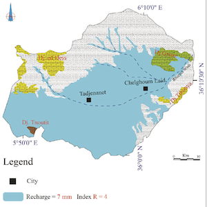
The region of Chelghoum Laid - Tadjenanet is located in the east of Algeria in the high southern plains of Setif, characterized by a highly vulnerable shallow alluvial aquifer. The vulnerability of groundwater to pollutants is a relative concept, not measurable or dimensional. The nature, quality, and reliability of used data used have a major impact on the correctness of its assessment. Its classification is usually based on the estimation of many more or less essential factors, such as the characteristics of soil and unsaturated zone, the saturated zone, the recharge , the topography and the hydraulic conductivity. The vulnerability of the aquifer to pollution was investigated using two intrinsic vulnerability methods: DRASTIC and susceptibility index (SI). SI method is an adaptation of the DRASTIC specifically design for nitrate-based pollution. The parameters used as input data are, among others, the depth of the groundwater, the soil type, the topographic slope and the groundwater recharge. The validity of the two methods for assessing the vulnerability to nitrates was established by comparing the distribution of these elements in groundwater with the distribution of the various vulnerability classes. GIS techniques were used to implement these methods. Vulnerability maps created using the DRASTIC and SI method’s depict the potential for pollutants to penetrate and spread in these locations depending on the terrain encountered on the surface and the depth of the aquifer. The comparison revealed that the SI technique is the most accurate in the studied alluvial aquifer. The establishment of the pollution vulnerability map highlighted an area of great vulnerability in the center of the plain, reflected by the fragility of the soil and the shallow depth of the water. While the average vulnerability areas are in the center, and east at the periphery of Wadi Rhumel, the rest of the field is slightly vulnerable. The vulnerability and contamination risk maps created for this study are valuable tools for environmental planning and can be used for predictive management of groundwater resources. This case study suggests that the approach may be applicable to other areas as part of efforts to target groundwater management efforts.


Adams,B., & Foster, S.S.D. (1992). Land-surface Zoning for Groundwater Protection. Water and Environment Journal 6 (3):312–19. https://doi.org/10.1111/j.1747-6593.1992.tb00755.x DOI: https://doi.org/10.1111/j.1747-6593.1992.tb00755.x

AKE, G.E., Kouassi, D., Boyossoro, H.K., Brou, D., Mahaman, B.S., & Jean, B. (2009). Contribution of DRASTIC and GOD Intrinsic Vulnerability Methods to the Study of Nitrates Pollution in the Bonoua Region (South-East of Côte d’Ivoire). European Journal of Scientific Research 31 (1): 157–71.

Alam, F., Umar, R., Ahmed, S. & Dar, F.A. (2014). A new model (DRASTIC-LU) for evaluating groundwater vulnerability in parts of central Ganga Plain, India. Arabian Journal of Geosciences, vol. 7, no 3, p. 927-937. https://doi.org/10.1007/s12517-012-0796-y. DOI: https://doi.org/10.1007/s12517-012-0796-y

Aller, L., Truman, B., Lehr, J., Petty, R.J., & Glenn, H. (1987). DRASTIC: A Standardized System for Evaluating Ground Water Pollution Potential Using Hydrogeologic Settings. US Environmental Protection Agency. Washington, DC 455.

Aller, L. (1985). DRASTIC: a standardized system for evaluating ground water pollution potential using hydrogeologic settings. Robert S. Kerr Environmental Research Laboratory, Office of Research and Development, US Environmental Protection Agency. DOI: https://doi.org/10.1021/bk-1986-0315.ch008

Appelo, C.A.J., & Postma, D. (2004). Geochemistry, groundwater and pollution. CRC press. DOI: https://doi.org/10.1201/9781439833544

Ariffin, S.M., Mohamed, A.M.Z., & Hasfalina, C.M. (2016). Evaluation of Groundwater Pollution Risk (GPR) from Agricultural Activities Using DRASTIC Model and GIS. IOP Conference Series: Earth and Environmental Science 37 (1): 012078. https://doi.org/10.1088/1755-1315/37/1/012078 DOI: https://doi.org/10.1088/1755-1315/37/1/012078

Arfaoui, M., Aouiti, S., Azaza, F.H., & Zammouri, M. (2022). Assessment of groundwater vulnerability in coastal zone using SI method and GIS: case study of Bouficha aquifer (northeast Tunisia). Environmental Science and Pollution Research, 1-17. DOI: https://doi.org/10.1007/s11356-022-21053-9

Arzu Firat, E., & Fatma, G. (2013). DRASTIC-based methodology for assessing groundwater vulnerability in the Gümüshaciköy and Merzifon basin (Amasya, Turkey). Earth sciences research journal, 17(1), 33-40.

Brou, D., Kouassi, K .L., Kouame, K. I., Konan, K. S., Soumahoro, M., Konan, W. A.B.,&Gnakri, D. (2013). Evaluation de La Vulnérabilité à La Pollution Des Aquifères Des Formations Altérites à Partir Des Méthodes DRASTIC et SYNTACS: Cas de La Ville de M’bahiakro, Centre de La Côte d’Ivoire. Evaluation of the Vulnerability to Pollution of Aquifers of Alterite Formations from the DRASTIC and SYNTACS Methods: Case of the City of M’bahiakro, Center of Côte d’Ivoire. International Journal of Innovation and Applied Studies 2 (4): 464–76. Available: https://citeseerx.ist.psu.edu/viewdoc/download?doi=10.1.1.299.7315&rep=rep1&type=pdfCGG. (1973). Geophysical Survey Area Chelghoum Laid. DHW Mila-Algeria .

European Commission (1993). Corine land cover: technical guide. Office for Official Publications of the European Communities.

Engel, B., Navulur, K., Cooper, B., & Hahn, L. (1996). Estimating Groundwater Vulnerability to Nonpoint Source Pollution from Nitrates and Pesticides on a Regional Scale.

Ewodo, G. M . (2017). Contribution of the DRASTIC, GOD and SI Parametric Methods to the Assessment of Intrinsic Vulnerability in the Aquifers of the Abiergué Watershed (Yaoundé region). Life and Earth Sciences and Agronomy 4 (2). http://publication.lecames.org/index.php/svt/article/view/679

Ferreira, J.L., & Oliveira, M.M. (2004). Groundwater vulnerability assessment in Portugal. Geofísica internacional, 43(4), 541-550. DOI: https://doi.org/10.22201/igeof.00167169p.2004.43.4.783

Frances, A., Paralta, E., Fernandes, J.,& Ribeiro, L. (2001). Development and application in the Alentejo region of a method to assess the vulnerability of groundwater to diffuse agricultural pollution: the susceptibility index. In 3rd International Conference on Future Groundwater Resources at Risk, IAH/Unesco.

Fusco, F., Allocca, V., Coda, S., Cusano, D., Tufano, R., & De Vita, P. (2020). Quantitative assessment of specific vulnerability to nitrate pollution of shallow alluvial aquifers by process-based and empirical approaches. Water, 12(1), 269. DOI: https://doi.org/10.3390/w12010269

Hirata, R., & Bertolo, R. (2009). Groundwater vulnerability in different climatic zones. Groundwater-Volume II, 316.

Hosseini, M., & Saremi, A. (2018). Assessment and estimating groundwater vulnerability to pollution using a modified DRASTIC and GODS models (case study: Malayer Plain of Iran). Civil Engineering Journal, 4(2), 433-442. DOI: https://doi.org/10.28991/cej-0309103

Hrkal, Z. (2001). Vulnerability of Groundwater to Acid Deposition, Jizerské Mountains, Northern Czech Republic: Construction and Reliability of a GIS-Based Vulnerability Map. Hydrogeology Journal 9 (4): 348–57. DOI: https://doi.org/10.1007/s100400100141

Khedidja, A., & Boudoukha, A. (2014). Risk assessment of agricultural pollution on groundwater quality in the high valley of Tadjenanet- Chelghoum Laid (Eastern Algeria). Desalination and Water Treatment, 52(22-24), 4174-4182. DOI: https://doi.org/10.1080/19443994.2013.874702

Khedidja, A. (2016). Characterization of the hydrodynamic parameters of the Tadjnanet-Chelghoum Laid aquifer and the impact of surface water pollution on groundwater. Doctoral Thesis in Science. Univ. Batna 2. 162p.

Jarray, H., Zammouri, M., Ouessar, M., Hamzaoui-Azaza, F., Barbieri, M., Zerrim, A., ... & Yahyaoui, H. (2017). Groundwater vulnerability based on GIS approach: Case study of Zeuss-Koutine aquifer, South-Eastern Tunisia. Geofísica internacional, 56(2), 157-172. DOI: https://doi.org/10.22201/igeof.00167169p.2017.56.2.1763

Lallemand-Barrès (1994). Standardization of Criteria for Establishing Pollution Vulnerability Maps. Preliminary documentary study. BRGM report R 37928.

Marín, A.I., Andreo, B., & Mudarra, M. (2015). Vulnerability mapping and protection zoning of karst springs. Validation by multitracer tests. Science of the Total Environment, 532, 435-446. DOI: https://doi.org/10.1016/j.scitotenv.2015.05.029

Merchant, J.W. (1994). GIS-Based Groundwater Pollution Hazard Assessment: A Critical Review of the DRASTIC Model. Photogrammetric Engineering and Remote Sensing 60: 1117–1117.

Moratalla, Á., Gómez-Alday, J.J., Sanz, D., Castaño, S., & De Las Heras, J. (2011). Evaluation of a GIS-Based integrated vulnerability risk assessment for the mancha oriental system (SE Spain). Water resources management, 25(14), 3677-3697. DOI: https://doi.org/10.1007/s11269-011-9876-0

Murat, V., Paradis, D., Savard, M.M., Nastev, M., Bourque, E., Hamel, A., Lefebvre, R., & Martel, R. 2003. (2003). Groundwater vulnerability of fractured aquifers in southwestern Quebec: assessment using the DRASTIC and GOD methods. https://doi.org/10.4095/214216. DOI: https://doi.org/10.4095/214216

Ray, J.A., & O’dell, P.W. (1993). DIVERSITY: A New Method for Evaluating Sensitivity of Groundwater to Contamination. Environmental Geology 22 (4): 345–52. https://doi.org/10.1007/BF00767508. DOI: https://doi.org/10.1007/BF00767508

Ribeiro, L. (2000). Development of an Index to Assess the Susceptibility of Aquifers to Contamination. Internal Note, (not Published), ERSHA-CVRM 8.

Schnebelen, N., Platel, J. P., Nindre, Y. L., & Baudry, D. (2002). Groundwater Management In Aquitaine Year 5. Sector Operation. Protection of the Oligocene Aquifer in the Bordeaux Region [Water Management in Aquitaine 5. Sectorial Operation. Oligocene Aquifer Protection in the Bordeaux Region]. Report, BRGM, Orleans, France. http://infoterre.brgm.fr/rapports/RP-51178-FR.pdf.

Sinan, M. (2000). Methodology for the Identification, Evaluation and Protection of Water Resources in Regional Aquifers by Combining GIS, Geophysics and Geostatistics: Application to the Haouz Aquifer in Marrakech (Morocco). Mohammedia School of Engineers, Morocco.

Smida, H., Chokri, A., Moncef, Z., & Hamed, B.D. (2010). Mapping of Zones Vulnerable to Agricultural Pollution by the DRASTIC Method Coupled with a Geographical Information System (GIS): Case of the Chaffar Water Table (south of Sfax, Tunisia). Science and Planetary Change/Drought 21 (2): 131–46. DOI: https://doi.org/10.1684/sec.2010.0246

Stigter, T.Y., RIBEIRO, L., Carvalho, A.M.M.D. (2006). Evaluation of an Intrinsic and a Specific Vulnerability Assessment Method in Comparison with Groundwater Salinisation and Nitrate Contamination Levels in Two Agricultural Regions in the South of Portugal. Hydrogeology Journal 14 (1-2): 79–99. DOI: https://doi.org/10.1007/s10040-004-0396-3

Thirumalaivasan, D., Karmegam, M., Venugopal, K. (2003). AHPDRASTIC: Software for Specific Aquifer Vulnerability Assessment Using DRASTIC Model and GIS. Environmental Modelling & Software 18 (7): 645–56. https://doi.org/10.1016/S1364-8152(03)00051-3 DOI: https://doi.org/10.1016/S1364-8152(03)00051-3

Thiuone, P.B.D., Ndao, S., Alassanse, B. A., Diaw, E.H.B. (2017). Assessment of Groundwater Vulnerability by Susceptibility Index (SI) Method in the Niayes Area, Senegal. The Journal of Scientific and Engineering Research 4: 247–57.

Vrba, J., Zaporozec, A. (1994). Guidebook on Mapping Groundwater Vulnerability (International contributions to hydrology).

Zouhri, L., & Armand, R. (2021). Groundwater vulnerability assessment of the chalk aquifer in the northern part of France. Geocarto International, 36(11), 1193-1216. DOI: https://doi.org/10.1080/10106049.2019.1637465

Vila J.M. (1977). Carte géologique de l’Est algérien 1/20 000 avec notice explicative détaillée. Geological map of eastern Algeria 1/20000 with detailed explanatory note. Service of gelogical maps. Algeria, 0_3-4 Sétif.

Khedidja, A., Drias, T., & Reghais, A. (2023). Assessment of groundwater vulnerability to pollution using DRASTIC and the SI methods: case of the alluvial aquifer in Tadjenanet-Chelghoum laid (East Algeria). Acque Sotterranee - Italian Journal of Groundwater, 12(2), 37–47. https://doi.org/10.7343/as-2023-644

Downloads

Download data is not yet available.

Citations