Feasibility study for the southern extension of Mila town (northeast of Algeria) for urbanization purposes: a geotechnical and hydrogeophysical approach


Submitted: 16 January 2023
Accepted: 7 April 2023
Published: 28 June 2023
Abstract Views: 441
PDF: 330
Publisher's note
All claims expressed in this article are solely those of the authors and do not necessarily represent those of their affiliated organizations, or those of the publisher, the editors and the reviewers. Any product that may be evaluated in this article or claim that may be made by its manufacturer is not guaranteed or endorsed by the publisher.

Authors

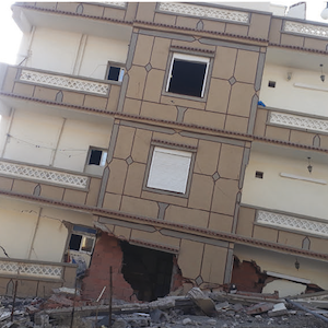
The population of Mila is increasing and local authorities are looking for new lands to develop the town and provide housing. However, the soil of these lands is unstable and requires detailed studies to serve as a foundation. This work presents the geotechnical and the geophysical characteristics of the Marechau soils, which forms the southeast extension of the Mila town. To provide an idea about the soil condition, to choose the type of adequate constructions and to make decision for building it, we adopted a geotechnical approach, where we analysed the soils by carrying out core drilling tests, dynamic penetration tests and the laboratory tests. We also, employed the geophysical approach in determining the electrical resistivity so as to map the depth of bedrock roof. Furthermore, we conducted a comprehensive hydrogeological study, monitoring precipitation and the piezometric level of the aquifer over a period of 200 days, and determined the flow direction. The core drilling test results indicate a clayey soil with limestone blocks. The dynamic penetration test show two categories of soil. The laboratory tests show that the materials analysed are very plastic, over-consolidated and medium to very compressible. They have a medium to high swelling potential and medium amount of aggressiveness to concrete. Besides, the tomography results also showed a single layer land (clay) with massive rocks embedded in it. The piezometric monitoring reveals the presence of two aquifer systems. The first is superficial and the second is deep. They don’t recharge directly after the rain falls and the groundwater flows in the direction of the slope. All the results indicate that solutions must be found for soil movements in the area under study before urbanization takes place. The combination of these results with the location, land morphology, tectonic activity, and seismotectonic aspects suggest that the area presents a high risk, and its urbanization requires rigorous and mandatory precautionary measures.


Abbes, K., Dorbath, L., Dorbath, C., Djeddi, M., Ousadou, F., Maouche, S., Benkaci, N., Slimani, A., Larbes, S., & Bouziane, D. (2015). The BeniHaoua, Algeria, Mw 4.9 earthquake: source parameters, engineering, and seismotectonic implications. Journal of Seismology,20(2), 655–667. DOI: https://doi.org/10.1007/s10950-015-9549-1

Abbouda, M., Maouche, S., Bouhadad, Y., & Belhai D. (2019). Neotectonics and active tectonics of the Dahra - Lower Cheliff Basin (Tell Atlas, Algeria): seismotectonic implication. Journal of African Earth Sciences, 153. http//doi.org/10.1016/j.jafrearsci.2019.02.023. DOI: https://doi.org/10.1016/j.jafrearsci.2019.02.023

AicheGéo-Sol (Laboratoire d’Études Géotechniques de Sols et Fondations) (2013). Étude géotechnique du POS AU15 sur une surface de 40 ha. Commune de Mila: phase de reconnaissance phase de synthèse III - wilaya de Mila. Geotechnical study of AU15 POS at 40 ha of surface. Mila Commune: reconnaissance phase, synthesis phase III - Mila wilaya. File N EG43/12/2013 (in French).

Alijani-Shirvani, R., & Shooshpasha, I. (2015). Experimental Study on Load-Settlement Behaviour of Cement Stabilised Footing with Different Dimensions on Sandy Soil. Arab J SciEng, 40:397–406. https://doi.org/10.1007/s13369-014-1444-5. DOI: https://doi.org/10.1007/s13369-014-1444-5

Aoudia, A., Vaccari, F., Suhadolc, P., & Meghraoui, M. (2000). Seismogenic potential and earthquake hazard assessment in the Tell Atlas of Algeria. J. of Seismology, 4: 79-98. DOI: https://doi.org/10.1023/A:1009848714019

Athmania, D. (2010). Minéralogie des argiles et phénomène de retrait– gonflement dans le bassin de Mila (Nord Constantinois). Mineralogy of clays and shrinkage-swelling phenomenon in the Mila basin (North Constantinois). PhD Thesis, University of Constantine, 172 p (in French).

Ayadi, A., & Bezzeghoud, M. (2015). Seismicity of Algeria from 1365 to 2013: Maximum Observed Intensity Map (MOI 2014). Seismological Research Letter, 86 (1). http://srl.geoscienceworld.org/content/86/1/236.full. DOI: https://doi.org/10.1785/0220140075

Azzouz, F.Z. (2015). Stabilisation des sols argileux de la région de Tlemcen par les sels. Stabilization of clay soils in the Tlemcen region by salts. El Wahat Journal for Research and Studies, 8 (1):108-117. DOI: https://doi.org/10.54246/1548-008-001-060

Beldjoudi, H., Delouis, B., Djellit, H., Yelles-Chaouche, A., Gharbi, S., & Abacha, I. (2016). The Beni-Ilmane (Algeria) seismic sequence of May 2010: seismic sources and stress tensor calculations. Tectonophysics, 670:101–114. https://doi.org/10.1016/j.tecto.2015.12.021. DOI: https://doi.org/10.1016/j.tecto.2015.12.021

Benabbas, C. (2006). Évolution Mio-Plio-Quaternaire des bassins continentaux de l’Algérie Nord orientale: apport de la photogéologie et analyse morphostructurale. Mio-Plio-Quaternary evolution of the continental basins of North-Eastern Algeria: contribution of photogeology and morphostructural analysis. PhD Thesis, University of Constantine (in French).

Benfedda, A., Serkhane, A., Bouhadad, Y., Slimani, A., Abbouda, M., & Bourenane, H. (2021). The main events of the July–August 2020 Mila (NE Algeria) seismic sequence and the triggered landslides. Arabian Journal of Geosciences, 14:1894. https://doi.org/10.1007/s12517-021-08301-x. DOI: https://doi.org/10.1007/s12517-021-08301-x

Benfedda, A., Abbes, K., Bouziane, D., Bouhadad, Y., Slimani, A., Larbes, S., Haddouche, D., & Bezzeghoud, M. (2017). The August 1st, 2014 (Mw 5.3) Moderate Earthquake: Evidence for an Active Thrust Fault in the Bay of Algiers (Algeria). Pure Appl. Geophys, 174: 1503–1511. https://doi.org/10.1007/s00024-017-1481-6. DOI: https://doi.org/10.1007/s00024-017-1481-6

Benouar, D. (1994). Material for the investigation of the seismicity of Algeria and adjacent regions during the twentieth century. Annali di geofisica XXXVII. DOI: https://doi.org/10.4401/ag-4466

Bouhadad, Y. (2008). Probabilistic seismic hazard assessment in eastern Algeria. Cahiers du Center Européen de Géodynamique et de Sismologie (ECGS) 28: 89-94.

Bounif, A., Haesler, H., & Meghraoui, M. (1987). The Constantine (Northeast Algeria) earthquake of October 27, 1987: surface ruptures and aftershocks study. Eart.Plan. Sc. Let. 85: 451-460. DOI: https://doi.org/10.1016/0012-821X(87)90140-3

Brencich, A., & Gnecco, M. (2012). Failure case studies engineering courses and professional practice. ASCE J. 37(8); 2113–2126. DOI: https://doi.org/10.1007/s13369-012-0292-4

Chanda, D., Saha, R., &Haldar, S. (2019). Influence of Inherent Soil Variability on Seismic Response of Structure Supported on Pile Foundation. Arabian Journal for Science and Engineering, 44: 5009-5025. https://doi.org/10.1007/s13369-018-03699-1. DOI: https://doi.org/10.1007/s13369-018-03699-1

Chen, Y., Li, B., Xu, Y., Zhao, Y., & Xu, J. (2019). Field Study on the SoilWater Characteristics of Shallow Layers on Red Clay Slopes and Its Application in Stability Analysis. Arabian Journal for Science and Engineering, 44: 5107-5116. https://doi.org/10.1007/s13369-018-03716-3. DOI: https://doi.org/10.1007/s13369-018-03716-3

Chettah, W. (2009). Investigation des propriétés minéralogiques et géomécaniques des terrains en mouvement dans la ville de Mila «Nord-Est d’Algérie ». Investigation of the mineralogical and geomechanical properties of moving terrain in the city of Mila «Northeast of Algeria». Magister memory, El Hadj Lakhdar-Batna University (in French).

Coiffait, P. E. (1992). Un bassin post-nappe dans son cadre structural, exemple du bassin de Constantine (Algérie orientale). A postgroundwater basin in its structural framework, example of the Constantine basin (Eastern Algeria). PhD thesis in science. Université de Nancy (in French).

Cordary, D. (1994). Mécanique des sols. Mechanic of soils. Lavoisier ed. Tec and Doc. Paris (in French).

Costet, J., & Sanglerat, G. (1981). Cours pratique de mécanique des sols. Tome 1 - Plasticité et calcul des tassements. Practical course in mechanics of soils. Volume 1 - Plasticity and settlement calculation. Dunod ed. Paris (in French).

Dakshanamurthy, V., & Raman, V. (1973). A simple method of identifying an expansive soil. Soils and Foundations. Japanese Soc. Of Soil Mech. And Foundation Eng, 13(1): 97-104. DOI: https://doi.org/10.3208/sandf1972.13.97

Derriche, Z., Guechtal, L., & Tas, M. (1999). Comportement des ouvrages dans les argiles expansives d’In-Aménas. Behavior of structures in expansive clays of In-Aminas. French Geotechnical Journal, 86: 55-63 (in French). DOI: https://doi.org/10.1051/geotech/1999089055

Durand-Delga, M. (1955). Etude géologique de l’Ouest de la chaîne Numidique. Western geological survey of the Numidic chain. PhD thesis, Paris. Publ. Serv. Carte Géol. Algérie, 2e Sér, Bull. 24 (in French).

El Yakoubi, N. (2006). Potentialités d’utilisation des argiles marocaines dans l’industrie céramique: cas des gisements de JbelKharrou et de Benhmed (Meseta marocaine occidentale). Potential uses of Moroccan clay in the ceramic industry: case of the Jbel Kharrou and Benhmed deposits (western Moroccan meseta). PhD thesis, Mohammed V-Agdal University, Rabat Faculty of Science (in French). DOI: https://doi.org/10.1016/j.crte.2006.03.017

Géoexplo (Bureau d’étude géophysique et exploration). (2015). Etude des glissements de terrain dans la wilaya de Mila par approche géophysique. Study of landslides in the wilaya of Mila by geophysical approach (in French).

Habila, S., Khelili, S., & Legouchi, E. (2010). Assessment of the risk of contamination of the waters of the Beni Haroun Dam (Wilaya de Mila) by organic pollutants and minerals. “International Network Environmental Management Conflicts, Santa Catarina Ŕ Brasil”, 1(1), pp. 239-245 (in French).

Hadji,R., Rais, K., Gadri, L., Chouabi, A., &Hamed, Y. (2016). Slope Failure Characteristics and Slope Movement Susceptibility Assessment Using GIS in a Medium Scale: A Case Study from OuledDriss and Machroha Municipalities, Northeast Algeria. Arab J Sci Eng, 42: 281-300. DOI 10.1007/s13369-016-2046-1. DOI: https://doi.org/10.1007/s13369-016-2046-1

Hamidatou, M., & Sbartai, B. (2015). Probabilistic seismic hazard assessment in the Constantine region, Northeast of Algeria. Arab J Geosci, 10:156. https://doi.org/10.1007/s12517-017-2876-5. DOI: https://doi.org/10.1007/s12517-017-2876-5

Harbi, A., Maouche, S., & Ayadi, A. (1999). Neotectonics and associated seismicity in the Eastern Tellean Atlas of Algeria. J. Seismol, 3: 95-104. DOI: https://doi.org/10.1023/A:1009743404491

Harbi, A., Meghraoui, M., & Maouche, S. (2011). The Djidjelli (Algeria) earthquakes of 21 and 22 August 1856 (Io=VIII, IX) and related tsunami effects. Reviaread. J Seismol, 15(1):105-129. DOI: https://doi.org/10.1007/s10950-010-9212-9

Hazmoune, H. (2008). Approches des études géotechniques liées à la pathologie des ouvrages: étude de cas des 185 logements de Mila. Approaches to geotechnical studies related to the pathology of structures: case study of 185 dwellings in Mila. Magister memory, University of Constantine, 86 p (in French).

Kateb, Z., Bouchelkia, H., Benmansour, A., & Belarbi, F. (2020). Sediment transport modeling by the SWAT model using two scenarios in the watershed of Beni Haroun dam in Algeria. Arab J Geosci 13, (653):1-17. https://doi.org/10.1007/s12517-020-05623-0. DOI: https://doi.org/10.1007/s12517-020-05623-0

Khellaf, K.,& Bitat, F. (2006). Etude géotechnique et géologique des 185 logements (Mila) et proposition de solutions aux problèmes posés. Geotechnical and geological study of 185 dwellings (Mila) and proposal of solutions to the problems raised. Engineer memory, Jijel University (in French).

Khellaf, K. (2009). Cadre géologique, aspect pétro-minéralogique et géotechnique du complexe argilo-marneux de la région Nord-Ouest de la ville de Mila: Boufouh (Mila-Algérie (Nord orientale).

“Geological, petro-mineralogical and geotechnical aspect of the clay-marl complex of the North-West region of the city of Mila: Boufouh (Mila-Algérie (North-East)”. Magister Memory, Cheikh Larbi Tébessi- Tébessa University, 156p (in French).

Khellaf, K., Zeroual, F., Sebaai, N., & Aziz, W. (2015). L’effet de l’ajout du sable de Sidi Abd el Aziz (Jijel) sur le potentiel du gonflement des argiles de Mila (région d’el kherba). The effect of the addition of the sand of Sidi Abd el Aziz (Jijel) on the potential swelling of the Mila clay (El Kherba region). El Wahat for Research and Studies, 8(2): 57 – 77 (in French). DOI: https://doi.org/10.54246/1548-008-002-033

Khellaf, K., & Hamimed, M. (2018a). Contribution to the geotechnical study and estimation for differential settlements of Mila region soils (North-East Algeria). JARST 5(2): 818-828.

Khellaf, K., & Hamimed, M. (2018b). Petro-Mineralogical and Geotechnical Analysis on the Clays of Constantinois Province (Mila North-East Algeria). J. Appl. Environ. Biol. Sci, 8(2):14-22.

Khellaf, K., & Hamimed, M. (2018c). Geotechnical study and estimation for differential settlements risk of Mila-Constantine basin soils (north-east Algeria). El Wahat pour les Recherches et les Etudes, 11(1): 109-126.

Khellaf, K. (2019). Cadre géologique, minéralogique et analyses des différents paramètres des formations argileuses variées en zone occidentale du bassin de Mila, Algérie Nord orientale. Geological, mineralogical framework and analyses of the various parameters of the various clay formations in the western zone of the Mila basin, Algeria North East. PhD thesis, University of Tebessi, Tebessa (in French).

Kherroubi, A., Deverchère, D., Yelles, A., Mercier de Lepinay, B., Domzig, A., Cattaneo, A., Bracene, R., Gaullier, V., & Graindorge, D. (2009). Recent and active deformation pattern off the easternmost Algerian margin, western Mediterranean sea: New evidence of contractional tectonic reactivation. Marine Geology, 261: 17-32. DOI: https://doi.org/10.1016/j.margeo.2008.05.016

Komornik, A., & David, D. (1969). Prediction of swelling pressure of clays. Journal of Soil Mechanics and Foundation Engineering Division ASCE, 95 (1): 209-225. DOI: https://doi.org/10.1061/JSFEAQ.0001218

Labiod, F. (2009). Mouvement de masses et instabilités des terrains dans le bassin versant de l’oued Mila. Caractérisations et enjeux socio-économiques. Mass movement and land instability in the Wadi Mila watershed. Characterizations and socio-economic issues. Magister memory, University of Science and Technology – Houari Boumediene- Algiers (in French).

LBM-Sol (Laboratoire de Béton et de Mécanique de Sol). (2014). Rapport d’étude géotechnique: Plan d’occupation de sol N°9 Mil. (2ème et 3ème phase). Geotechnical Study Report: Land Use Plan 9 Mil. (2nd and 3rd phase). File 32/2012 (in French).

LNHC (Laboratoire Nationale de l’Habitat et de Construction). (2001). Rapport d’étude géotechnique complète du POS de Mila. Comprehensive geotechnical study report of the Mila POS. File 133/2001. OPGI de Mila (in French).

Loke, M.H., & Barker, R.D. (1995). Least-square deconvolution of apparent resistivity pseudo-sections. Geophysics 60(6):499-523. DOI: https://doi.org/10.1190/1.1443900

Maouche, S., Meghraoui, M., Morhange, C., Belabbes, S., Bouhadad, Y., & Haddoum, H. (2011). Active coastal thrusting and folding, and uplift rate of the Sahel Anticline and Zemmouri earthquake area (Tell Atlas, Algeria). Tectonophysics, 509: 69-80. https://doi.org/10.1016/j.tecto.2011.06.003.4. DOI: https://doi.org/10.1016/j.tecto.2011.06.003

Mebarki, A. (1984). Ressources en eau et aménagement en Algérie. Le bassin du Kébir Rhumel. Springs and development in Algeria. The Kébir Rhumel basin. University Publication Office Ed. 8, Algiers (in French).

Mebarki, A., & Thomas, C. (1988). Analyse des relations entre écoulements superficiels et souterrains à partir des hydrogrammes des cours d’eau: application au bassin du Kebir-rhumel dans le Constantinois (Algérie). Analysis of the relationships between surface and underground flows from river hydrographs: application to the Kebirrhumel basin in Constantinois (Algeria). Continental Hydrology, 3(2), 89-103. ISSN 0246-1528 (in French).

Meghraoui, M. (1988). Géologie des zones sismiques du Nord de l’Algérie. Paléosismologie, tectonique active et synthèse sismotectonique. Geology of seismic zones in northern Algeria. Paleoseismology, active tectonics and seismotectonic synthesis.PhD thesis, Univ. Paris VI (in French).

Mutlutürk, M., & Balcıoglu, E. (2015). Geo-Engineering Properties and Swelling Potential of Quaternary Lacustrine Clays in North of Burdur, Turkey.Arabian Journal for Science and Engineering 40:1917–1931. https://doi.org/10.1007/s13369-014-1505-9. DOI: https://doi.org/10.1007/s13369-014-1505-9

NF P18-011. (1992). Sols: Reconnaissance et Essais: Classification des environnements agressifs. Soils: Recognition and Testing: Classification of Aggressive Environments. Certified June, Bull, lab link. P. and Ch (in French).

NF P94-050. (1994). Sols - Reconnaissance et Essais: Détermination de la teneur en eau pondérale des sols - Méthode par étuvage. Soils - Recognition and Testing: Determination of water-weight content of soils - Steaming method. Registered October 1991. Bull, liaison labo. P. and Ch. 190 (in French).

NF P94-053. (1994). Sols - Reconnaissance et Essais: Détermination de la masse volumique des sols fins en laboratoire - Méthode de la trousse coupante, du moule et de l’immersion dans l’eau. Soils - Recognition and Testing: Determination of the density of fine soils in the laboratory - Method of cutting kit, mould and immersion in water. Approved October 1991. Bull, lab liaison. P. and Ch (in French).

NF P94-057. (1994). Sols - Reconnaissance et Essais: Analyse granulométrique des sols par sédimentation. Soils - Recognition and Testing: Particle size analysis of soils by sedimentation. Approved May 1992. Bull, lab link. P. and Ch (in French).

NF P94-090-1. (1997). Sols: Reconnaissance et Essais - Essai oedométrique - Partie 1: Essai de compressibilité sur matériaux fins quasi saturés avec chargement par paliers. Soils: Recognition and Testing - Oedometrical Testing - Part 1: Compressibility Testing on Near- Saturated Fine Materials with Step Loading 55p (in French).

Parker, W. L. (1977). Understanding inverse theory. Ann Rev Earth Planet Sci. 1977: 5: 35-64. DOI: https://doi.org/10.1146/annurev.ea.05.050177.000343

Philipponnat, G. (1979). Fondations et ouvrages en Terre. Foundations and Earth structures. Eyrolles ed. (Paris) (in French).

Philipponnat, G., & Hubert, B. (2003). Fondations et ouvrages en terre. Foundations and Earth structures. Eyrolles ed. (Paris) (in French).

Rollings, R.S., Burkes, J. P., &Rollings, M. P. (1999). Sulfate Attack on Cement-Stabilized Sand. Journal of Geotechnical and Geoenvironmental Engineering,125(5): 364-372. DOI: https://doi.org/10.1061/(ASCE)1090-0241(1999)125:5(364)

Saadali, B., Khedidja, A., Mihoubi, N., Ouddah, A., Djebassi, T., & Kouba, Y. (2020). Water quality assessment and organic pollution identification of Hammam-Grouz dam (Northeastern Algeria). Arabian Journal of Geosciences, 13 (20), 1091. DOI: https://doi.org/10.1007/s12517-020-06117-9

Suiki, S. (2007). Les argiles du bassin de Constantine-Mila: composition minéralogique, chimique et répartition des gisements. The clays of the Constantine-Mila basin: mineralogical, chemical composition and distribution of deposits. Magister memory, Univ. Constantine, 129 pp (in French).

Tebbouche, M. Y., Ait Benamar, D., Hany, M. H., Singh, A.P., Bencharif, R., Machane, D., Aghiles Meziani, A., & Nemer, Z. (2022). Characterization of El Kherba landslide triggered by the August 07, 2020, Mw =4.9 Mila earthquake (Algeria) based on post event field observations and ambient noise analysis. Environmental Earth Sciences, 81:46. https://doi.org/10.1007/s12665-022-10172-8. DOI: https://doi.org/10.1007/s12665-022-10172-8

Touati,F. (2019). Étude géophysique, géologique, géotechnique de l’aléa naturel du glissement de terre cas de commune (Ain Tinn) wilaya de Mila. Geophysical, geological, geotechnical study of the natural hazard of the landslide: case of Ain Tine commune, wilaya de Mila. Magister memory, Ferhat Abbas Sétif University 1, 96p (in French).

Vila, J. M. (1980). La chaîne alpine d’Algérie orientale et des confins algéro-tunisiens. The Alpine chain of Eastern Algeria and the Algerian-Tunisian borders. PhD thesis, Paris VI2 (in French).

Zouaoui, S. (2008). Étude géologique et géotechnique des glissements de terrains dans le bassin néogène de Mila: glissement de Sibari. Geological and geotechnical study of landslides in the Mila Neogene Basin: Sibari Landslide. Magister memory, El Hadj Lakhdar- Batna University (in French).

Khellaf, K., Bechkit, M. A., Chettah, W., Youcef Brahim, E. H., & Dib, I. (2023). Feasibility study for the southern extension of Mila town (northeast of Algeria) for urbanization purposes: a geotechnical and hydrogeophysical approach. Acque Sotterranee - Italian Journal of Groundwater, 12(2), 49–64. https://doi.org/10.7343/as-2023-630

Downloads

Download data is not yet available.

Citations