The Nationwide Water Budget Estimation in the light of the New Permeability Map of Italy


Submitted: 23 May 2022
Accepted: 26 September 2022
Published: 28 September 2022
Abstract Views: 644
PDF: 491
Publisher's note
All claims expressed in this article are solely those of the authors and do not necessarily represent those of their affiliated organizations, or those of the publisher, the editors and the reviewers. Any product that may be evaluated in this article or claim that may be made by its manufacturer is not guaranteed or endorsed by the publisher.

Authors

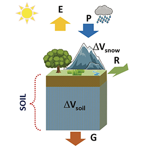
The hydrological budget is one of the fundamental tools for the sustainable management of water resources. In the last decades, the knowledge of the distribution of freshwater resources in space and time is becoming of great concern due to the growing pressure related to increasing population, water pollution, and climate change. Furthermore, in the scope of hydrological balance, the estimation of aquifer assumes particular concern in Italy. In fact, more than 80% of water withdrawal for domestic and drinkable use is derived from groundwater. In this context, the Italian Institute for Environmental Protection and Research (ISPRA) has developed a mathematical model for estimating the hydrological budget components at a national and macro-regional scale called BIGBANG. The aquifer recharge is estimated as a percentage of the monthly soil water surplus by the potential infiltration coefficient defined as a function of the permeability of the hydrogeological complexes beneath the soil layer. In this paper, a comparison highlighting the differences between the estimations of the long-term annual average of two of the main hydrological budget components, aquifer recharge and surface runoff, at national and sub-national levels, is carried out. The estimations are based on the new and more detailed Permeability Map of Italy produced by ISPRA and on the old map of the hydrogeological complexes currently used at national level used so far in the BIGBANG budget model.


Allocca V, Manna F, De Vita P, (2013) Estimating annual effective infiltration coefficient and groundwater recharge for karst aquifers of the southern Apennines. Hydrol. Earth Syst. Sci. Discuss., 10, 10127–10159

Allocca V, Celico F, Celico P, De Vita P, Fabbrocino S, Mattia C, Monacelli G, Musilli I, Piscopo V, Summa G, Tranfaglia G (2007) Hydrogeological map of Southern Italy. Poligrafico dello Stato. ISBN 88-448-0223-6

Amanti M, Battaglini L, Campo V, Cipolloni C, Congi MP, Conte G, Delogu D, Ventura R, Zonetti C (2008) The Lithological Map of Italy at 1:100,000 scale: An example of re-use of an existing paper geological map. In: Proceedings of the 33rd International Geological Conference. August 2008, Oslo (Norway)

Boni C F, Bono P, Capelli G (1982) Valutazione quantitativa dell’infiltrazione efficace in un bacino carsico dell’Italia centrale. Confronto con analoghi bacini rappresentativi di diversa litologia “Quantitative evaluation of effective infiltration in a karst basin of central Italy. Comparison with analogous basins having different lithology”. Geologia Applicata e Idrogeologia, 17: 437-451.

Boni CF, Bono P, Capelli G. (1986) Schema Idrogeologico dell’Italia Centrale – A) Carta idrogeologica (scala 1:500.000); B) Carta idrologica (scala 1:500.000); C) Carta dei bilanci idrogeologici e delle risorse idriche sotterranee (scala 1:1.000.000) – Mem. Soc. Geol. It. , 35 (2): 991-1012.

Braca G, Ducci D (2018) Development of a GIS based procedure (BIGBANG 1.0) for evaluating groundwater balances at National scale and comparison with groundwater resources evaluation at local scale. In Groundwater and Global Change in the Western Mediterranean Area (pp. 53-61). Springer, Cham.

Braca G, Bussettini M, Ducci D, Lastoria B, Mariani S (2019) Evaluation of national and regional groundwater resources under climate change scenarios using a GIS-based water budget procedure. Rend. Fis. Acc. Lincei, 30(1), 109–123. DOI:10.1007/s12210-018-00757-6

Braca G, Bussettini M, Lastoria B, Mariani S, Piva F (2021) Il Bilancio Idrologico Gis BAsed a scala Nazionale su Griglia regolare – BIGBANG: metodologia e stime. Rapporto sulla disponibilità naturale della risorsa idrica. “The Nationwide Regular Gridded Gis BAsed Water Balance - BIGBANG: methodology and estimates. Report on the availability of the renewable freshwater resources”. Italian Institute for Environmental Protection and Research, Report n.339/21, Rome.

British Geological Survey (2010) BGS permeability. https://www.bgs. ac.uk/products/hydrogeology/ permeability.html. Cited 29 October 2019

British Geological Survey (2021). User guide: BGS Permeability version 8. British Geological Survey Open Report, OR/20/054. 34pp. DOI:10.5285/e2a05b99-ac06-415d-836b-e3bf37fe7191

Celico P (1988) Prospezioni idrogeologiche. “Hydrogeological surveys”. Liguori Editore, Napoli

Civita MV (2008) L'assetto idrogeologico del territorio italiano: risorse e problematiche. - The hydrogeological structure of the Italian territory: resources and problems. Quaderni della Societa Geologica Italiana

Ducci D, Tranfaglia G (2008) The Effect of Climate Change on the Hydrogeological Resources in Campania Region (Italy). In Dragoni W. (ed) Groundwater and climatic changes. Geological Society, London, S. P., 288, 25-38 doi:10.1144/SP288.3.

Ducci D, Sellerino M (2015) Groundwater mass balance in urbanized areas estimated by a groundwater flow model based on a 3D hydro stratigraphical model: the case study of the eastern plain of Naples (Italy). Water Resources Management, 29 (12): 4319-4333. DOI: 10.1007/s11269-015-1062-3

European Commission (2015) Guidance document on the application of water balances for supporting the implementation of the WFD. ISBN 978-92-79-52021-1. doi: 10.2779/352735

Eurostat/OECD (2021) Data collection manual for the OECD/Eurostat Joint Questionnaire on Inland Waters Version 4.1

Gafà RM, Martarelli L, Monti GM, Silvi A, La Vigna F (2019) Preliminary elaboration of a Permeability Map of Italy Starting from the Information of the Lithological Map of Italy. Acque Sotterranee - Italian Journal of Groundwater, 8(4). https://doi.org/10.7343/as-2019-441

Gleeson T, Smith L, Moosdorf N, Hartmann J, Durr HH, Manning AH, Van Beek LPH, Jellinek AM (2011) Mapping permeability over the surface of the Earth. Geophysical Research letters, Vol. 38 L02401, doi:10.1029/2010GL045565.

Healy RW, Winter TC, La Baugh JW, Franke OL (2007) Water budgets: Foundations for effective water resources and environmental management. U.S.Geological Survey Circular 1308, 90 p

Herrmann F, Keller L, Kunkel R, Vereecken H, Wendland F (2015) Determination of spatially differentiated water balance components including groundwater recharge on the Federal State level – A case study using the mGROWA model in NorthRhine-Westphalia (Germany). Journal of Hydrology: Regional Studies 4 (2015) 294–312.

Huscroft J, Gleeson T, Hartmann J, Börker J (2018) Compiling and mapping global permeability of the unconsolidated and consolidated Earth: GLobal HYdrogeology MaPS 2.0 (GLHYMPS 2.0). Geophysical Research Letters, 45, 1897–1904. https://doi.org/10.1002/2017GL075860.

Kannangara D, Sarukkalige R (2011) Geotechnical assessment of soil permeability in land development areas. 2nd International Conference on Environmental Engineering and Applications IPCBEE vol. 17.

Istat (2021) Water losses in public water supply increased reaching 42.0% of the total input volume. https://www.istat.it/it/files//2021/01/UrbanWaterCensus2018_Dec2020.pdf. Accessed 25 april 2022.

Jean Olivier KK, Brou D, Jules MoM, Georges ES, Frédéric P, Didier G (2022) Estimation of Groundwater Recharge in the Lobo Catchment (Central-Western Region of Côte d’Ivoire). Hydrology 2022, 9, 23. https://doi.org/10.3390/hydrology9020023

Lewis MA, Cheney CS, ODochartaigh BE (2006) Guide to permeability indices. British Geological Survey Open Report, CR/06/160N. 29pp.

Mouton J, Mangano F, Fried JJ (1982) Studio sulle risorse in acque sotterranee dell’Italia. “Study on groundwater resources of Italy”. Th Schafer GmbH. D. 3000 – Hannover

Portoghese I, Uricchio V, Vurro M (2005) GIS tool for hydrogeological water balance evaluation on a regional scale in semi-arid environments. Computers & Geosciences 31 15–27

Servizio Geologico d’Italia (2018) Carta Idrogeologica d’Italia - 1:50.000. Nuove Linee guida al rilevamento e alla rappresentazione della Carta Idrogeologica d’Italia. Modifiche ed integrazioni al Quaderno N. 5/1995 “Hydrogeological Map of Italy - 1:50.000 scale. New Guidelines to survey and mapping for the Hydrogeological Map of Italy. Modifications and integrations to Quaderno N. 5/1995”. Quaderni del Servizio Geologico d’Italia (ISPRA), serie III, vol. 14. http://www.isprambiente.gov. it/it/pubblicazioni/periodici-tecnici/i-quaderni-serie-iii-del-sgi/cartaidrogeologica-ditalia-alla-scala-1-50.000

Servizio Geologico Nazionale (1995) Carta Idrogeologica d’Italia - 1:50.000. Guida al rilevamento e alla rappresentazione “Hydrogeological Map of Italy - 1:50.000 scale. Guidelines to survey and mapping”. Quaderni del Servizio Geologico Nazionale, serie III, vol. 5. http://www.isprambiente.gov.it/it/pubblicazioni/periodici-tecnici/i-quaderni-serie-iiidel-sgi/carta idrogeologica-d2019italia-1-50-000-guida-alfia

Thornthwaite CW, Mather JR (1955) The water balance. Laboratory of Climatology, No. 8, Centerton NJ

Toth G, Jones A, Montanarella L (eds) (2013) LUCAS topsoil survey. Methodology, data, results. JRC Technical Reports. Luxembourg. Publications office of the European Union, EUR 26102—scientific, technical research series—ISSN 1831-9424 (online); ISBN 978-92-79- 32542-7; doi:10.2788/97922

Westenbroek SM, Engott JA, Kelson VA, Hunt RJ (2018) SWB Version 2.0—A Soil-Water-Balance code for estimating net infiltration and other water-budget components. U.S. Geological Survey Techniques and Methods, book 6, chap. A59, 118 p., https://doi.org/10.3133/tm6A59

Braca, G., Bussettini, M., Gafà, R. M., Monti, G. M., Martarelli, L. ., Silvi, A., & La Vigna, F. . (2022). The Nationwide Water Budget Estimation in the light of the New Permeability Map of Italy. Acque Sotterranee - Italian Journal of Groundwater, 11(3), 31–39. https://doi.org/10.7343/as-2022-575

Downloads

Download data is not yet available.

Citations