Numerical simulation of seawater intrusion in the lower Seybouse aquifer system, Algeria
All claims expressed in this article are solely those of the authors and do not necessarily represent those of their affiliated organizations, or those of the publisher, the editors and the reviewers. Any product that may be evaluated in this article or claim that may be made by its manufacturer is not guaranteed or endorsed by the publisher.
Authors
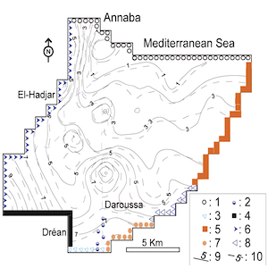
Seawater intrusion represents a high risk for the water supply, the agriculture and industry activities in the lower Seybouse region of North-Eastern Algeria. In order to analyze this risk, a three-dimensional model was developed using the MODFLOW and MT3DMS codes to predict seawater intrusion in the coastal aquifer. The application of this model indicates that the groundwater withdrawals result in a continuous decrease of the water level and in an increase of chloride concentration. Moreover, the salt front could progress by 300 to 2500 m in the land. These results show the necessity of adequate measures for the protection of the aquifer. Numerical predictions for 2045, considering an increase of groundwater withdrawals by 20%, show a fairly significant decrease in water levels, up to -6 m with respect to the mean sea level, and an increase of Cl- concentrations up to about 10 km inland.
Altmetrics
Downloads
Citations


Supporting Agencies
NoneHow to Cite

This work is licensed under a Creative Commons Attribution-NonCommercial 4.0 International License.
PAGEPress has chosen to apply the Creative Commons Attribution NonCommercial 4.0 International License (CC BY-NC 4.0) to all manuscripts to be published.